100 Years Ago From Where You Stand
First Hand Accounts From The Book Eruptions Of Lassen Peak By B.F. Loomis
By Melissa Wynn
Photos Courtesy of Lassen Volcanic National Park
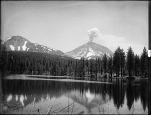
During the Memorial Day weekend of 1914 Lassen Peak awoke from a long silence and author Benjamin Franklin Loomis began documenting the historical series of eruptions.
“Saturday, May 30,1914. The first outbreak of the volcano occurred at 5:00 p.m. This was witnessed by Bert McKensie, of Chester, who was looking directly at it when it occurred. Forest Ranger Harvey Abbey investigated it Sunday, May 31st.”
Forest Supervisor Rushing sent the following report to the Courier Free Press at Redding:
“Mt. Lassen is in eruption from a new crater on the North slope close to the summit. The new crater is 25 feet wide, and 44 feet long, with deep fissures radiating in all directions. Lava and ashes shot up from the depths to cover an area 200 feet in diameter, to a depth varying from a foot to two feet. The new volcano is in eruption today, greater volumes of smoke and steam arising above the old sentinel peak than yesterday”
One of the most dramatic accounts is retold in a letter from Mr. Loomis to Mr. B.S. Holway of the University of California at Berkeley. This letter tells of an excursion up the mountain during the eleventh eruption, on June 14th 1914 that reads in part:
“I could not help thinking of those men who I knew must be near the mountain. Were they safe? Mr. R.E. Phelps and his mill crew, ten men in all, were camped at Manzanita Lake the night before. They struck camp early in the morning to climb the mountain to look at the crater. They went up on the North side right under where the heaviest smoke and ashes fell. Another party of five men also left the lake at 8:00 on the same mission. Mr. Phelps’ party had just reached the rim of the old crater and sat down to rest a short time, watching the smoke from the crater when the eruption began. Without any warning or explosion that could be heard, a huge column of black smoke shot upward with a roar, such as would be caused by a rushing mighty wind, and in an instant the air was filled with smoke, ashes and flying rocks from the crater. They all ran for their lives. Mr Phelps hid under an overhanging rock, which sheltered him from the rocks which brushed past him as they fell. Lance Graham was a few feet away when he was struck by a flying rock, which cut a great gash in his shoulder and broke his collar bone. He was left on the mountain for dead, for a time, but was afterward removed with great difficulty, and is now recovered.”
In an interview with the Shasta Courier Lance Graham said, “I have no idea how long I lay on the mountain side, but I was conscious of the fact that my companions had left me for dead. I was paralyzed: at least my vocal organs refused to respond to my efforts to articulate. When the eruption was over and the atmosphere cleared, my companions made a search for me, finding me completely covered with ashes and cinders.”
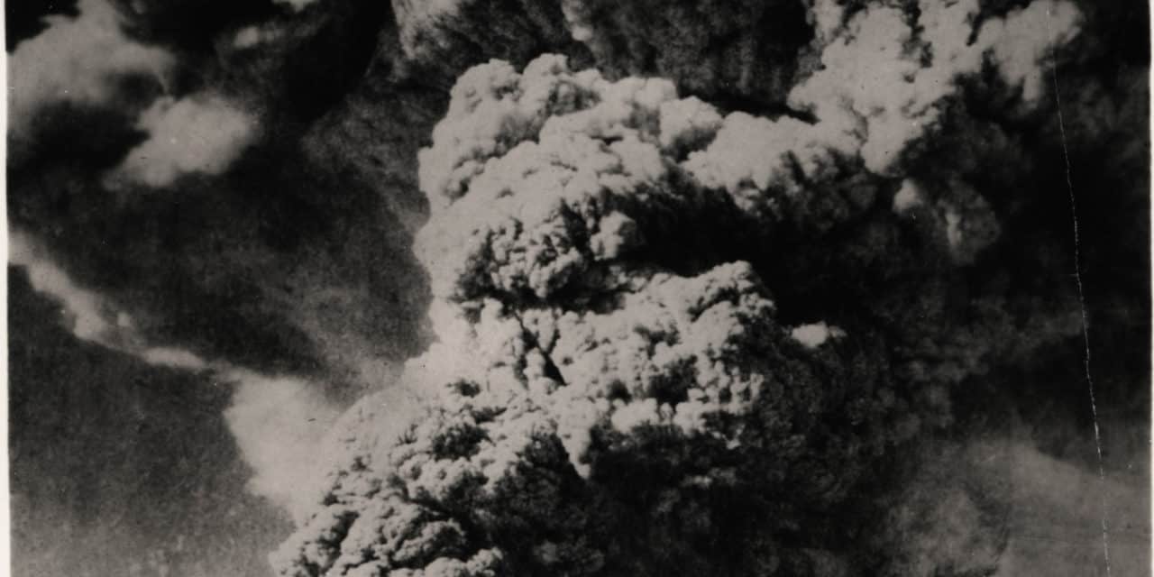
Several more eruptions, of varying degree, continued over the next few years with the biggest and most famous occurring on May 22, 1915. Once again Mr. Loomis was on hand to witness the devastation. Here is his a piece of his memoir:
“On the evening of Friday, May 21st, 1915, Mr. Bert Hall of Shingletown came to Viola and said the Wid Hall’s place on Hat Ceek had been washed away on the night before, and that they escaped with only their clothing, and that a cloud burst had occurred near Lassen Peak which had caused the flood.
The next morning, Saturday, May 22, a party of seven men from Viola, including myself, went over the mountain East of Lassen Peak to see if we could discover the cause of the flood, and see where the water came from.
On our way over, when we came near the upper end of Manzanita chute, we learned that the volcano was very active, blowing off about every fifteen minutes in medium size eruptions. I took a photograph of it on our way over from near the place where I had formerly taken our series of June 14, 1914.
When we arrived at Lost Creek where the Shasta Power Company’s ditch was taken out, four other men from Hat Creek joined us in our journey up the creek.
We reached the head of Lost Creek about noon, where we found that about all the water had come from the crater in Lassen Peak, which ran down the moun- tain side like a river. There was a great slit in the rocks on the East side of the peak where the water came from mostly, and all the water ran down on the Lost Creek side. The land on the hillside was well covered with timber before the flood, but the flood carried everything before it and not a tree was left in the path of the flood where it came down the mountain side, and for a long way down the creek.
There is a ridge or divide between Lost Creek and Hat Creek which slopes uphill for about a quarter of a mile. It has an elevation of about a hundred feet, but the water had gained such momentum that it flowed over this divide like a flood for the space of near a half a mile wide. This flood was from a few feet deep up to eighteen feet deep on the top of the divide, as was evidenced by the mud on the trees, and also by the bark which was peeled off, and the trunks of the trees were battered up to that height by floating debris, logs, trees and stones as they went flying past. Apparently about half of the water swirled around and went down Lost Creek, and the other half went down Hat Creek.
It is no exaggeration to say that the volume of water and mud in the two creeks must have been equal to that carried in the Sacramento River opposite Anderson at flood tide or high water mark. At the lower end of the Adams place on Lost Creek the valley is about two hundred yards wide and the mud on the trees showed that the mud flow was about twelve feet deep. All the meadow lands on both creeks are covered with rocks and debris, rendering them worthless and none of the buildings or fences remain. Many large rocks, some of them hot, were thrown from the crater, or torn off the lip of the crater on the west side, and carried down the creek by the raging torrents. A large hot rock appears in the foreground in my picture of Lassen Peak in eruption from the head of Lost Creek. The largest hot rock we saw was at the lower end of the Adams place where once his meadow used to be. The Lassen Park Road passes this rock which was very hot when it was deposited there by the mud flow. This rock is about 18 feet wide, 20 feet long, and I estimated it to be about 14 feet thick. It was carried four or five miles from the crater of Lassen Peak to where it now lies. And after forty hours from the time it left the crater it was still sizzling in the water. This story may seem incredible, but there were eleven of us who can verify the statement.”
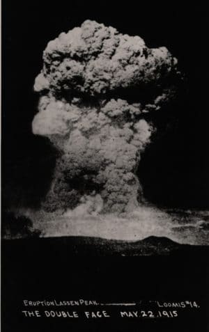
Mr. Loomis had a front row seat throughout the eruptive cycle and so did most of Northeastern California. From Westwood to Cottonwood, Susanville to Mineral, local residents watched in awe and horror as the May 22, 1915 eruption belched out a cloud of smoke, ash and steam that rose high in the air and was carried East by the wind. A steady rain of fine ash blanketed communities to the East including, Westwood and Susanville. Ash eventually found its way as far to the East as Winnemucca Nevada just over 300 miles away.
Visit your local museum or Lassen Volcanic National Park during this centennial anniversary of the big eruption and learn more about Mr. Loomis and what was happening where you are standing 100 years ago.


