
Greater Redding Area Trails
Story and photos by Dave Bartle
When it comes to trails and hiking, the Redding area is the jewel of Northern California. Boasting over 100 miles covered by 30 trails, the Greater Redding area is now a hiker’s and cyclist’s paradise. With the world famous Sundial Bridge acting as the launching point, you could conceivably hike all 30 trails with barely having to touch a paved road at all. Some are paved to allow for road bikes but the majority of the trails are dirt. They are all dog friendly and all the dirt trails accommodate mountain bikes and horses. No motorized vehicles are allowed on any of the trails; trailhead parking is free and many have a rest room.
From the Sundial Bridge, the paved Sacramento River Trail follows the Sacramento River to Shasta Dam. The adventurous mountain biker can follow this trail to the dam, cross it and pick up 25 miles of 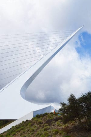 single-track in the Keswick Eastside Trail system. These trails can take you back to the Sundial Bridge. You can also access the Middle Creek, Salt Creek, and Westside Trails from the River Trail. From these trails you can connect to the Swasey Recreation Area trails and from there you can connect to the Mule Ridge trail. As an added bonus you can access dozens of miles in Whiskeytown NRA from both the Swasey and Mule Ridge systems.
Here is a breakdown of these trail systems:
Sacramento River Rail Trail (National Recreation Trail)
Nestled in the heart of Redding, this paved 11 mile trail follows the Sacramento River and the Keswick Reservoir all the way to Shasta Dam. The trail is highlighted by the Sundial Bridge located near Turtle Bay Museum. There’s an outdoor cafe that looks out over the river and offers a great view of the bridge. The trail is mostly flat with only one hill section to negotiate. Careful, it is steep and holds the nickname “Heart Rate Hill.” A spur to the FB trail can take you to the Eastside Keswick Trail system. Trailheads can be reached at the Redding Civic Center parking lot, Iron Mountain Road, the Rock Creek Road junction, the Keswick boat ramp, and along Keswick Dam Road.
Middle Creek, Salt Creek, and Westside Trails
Middle Creek trail is a paved, hilly three-mile trail running from the Sacramento River Trail to the historic town of Old Shasta. When you reach the town there is a great museum with displays of the area’s gold mining history. The Salt Creek Trail is dirt single-track that runs from the Middle Creek Trail to a trailhead off of Highway 299 to another trailhead off of Lower Springs Drive. The Westside trails can be accessed by parking at Mary Lake, Dillard Road, and the Salt Creek Trailhead at Lower Springs/Valparaiso.
Swasey Recreation Area
Boundless loops and terrain give this trail system plenty of challenging options for mountain bikers, horseback riders and hikers, too! Following the Mule Mountain Pass Trail up the “Terminator” or the Meiner’s Loop to the “Escalator” will take you to a perfectly placed picnic table at the pass. From there you can access Whiskeytown NRA and the Mule Ridge Trails. Or try a different side of the trail system and go up the Wintu Trail to get great views of the Sacramento Valley and the surrounding mountains. No matter which trail you take in this system you will be rewarded with a great hike or ride! Access the trailhead from Swasey Road.
The Mule Ridge Trail System
The latest additions to the Redding area trail system, these trails give hikers, mountain bikers and horseback riders 19 miles of single-track to navigate. It offers one of the great loop hikes in the area. This 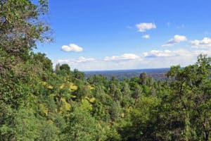 10 mile trail starts at the Oak Knoll Trail and climbs 800 plus feet to a ridge that gives you views of the Trinity Alps, Whiskeytown Lake and Shasta Bally. Continue down steep Cosmos Way, to the Princess Ditch Trail and back to the Oak Knoll Trailhead. Extra mileage credit can be earned by taking the Mule Mountain Loop Trail to the top of Mule Mountain. Trails can be accessed from two places on Mule Town Road, Placer Street, Whiskeytown National Recreation Area and the Swasey Recreation Area. Horse trailers are not recommended beyond the Oak Knoll Trailhead.
Clear Creek Greenway
A great warm weather option, this trail system offers swimming and fishing as well as hiking opportunities. The trail follows Clear Creek to the Clear Creek Gorge Overlook where in the fall you can 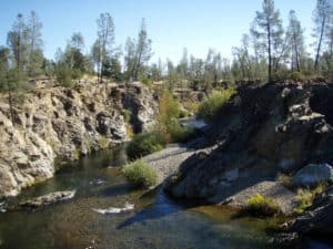 watch Chinook salmon spawning. The trail continues to the Horsetown Clear Creek Preserve and on to the Cloverdale Trails. Catch a view of Clear Creek Canyon from either of the two overlooks while you take a water break and have a snack. There are over 12 miles in this system. Reach the trailheads in several places along Clear Creek Road and Cloverdale Road.
For a map of these and other trails in the area visit:
http://www.blm.gov/style/medialib/blm/ca/pdf/redding.Par.39190.File.dat/Visit_Redding_Trails_Map.pdf


