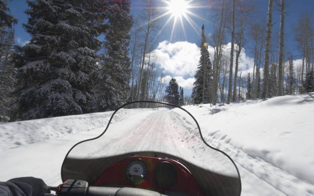
GRAEAGLE AREA TRAILS:
Lakes Basin Recreation Area – Just two miles south of Graeagle, the groomed Gold Lake Highway winds through the Lakes Basin Recreation Area, connecting highways 89 and 49. This area offers 38 miles of groomed routes for snowmobiling.
Gold Lake Highway – 14 miles, with two staging areas and restrooms at the northern and southern end of the highway. A restaurant is located at the southern end at Bassett’s Station.
Haskell Peak – 14 miles, accesses many large open areas for cross-country riding.
Howard Meadow – 6 miles, large open meadows, views of the Sierra Buttes. If ungroomed is challenging with stretches of severe side slope.
Mills Peak – 2 miles, forest route with great views.
Packer Lake – 2 miles, views of the Sierra Buttes.
Quincy area
Snake Lake Road – An easy, ungroomed six-mile road to the campground.
Squirrel Creek Road to Argentine Ridge
Indian Valley area
Antelope Lake Road – A scenic, ungroomed road east of Taylorsville.
Lights Creek Trail – ungroomed north of Taylorsville.
Old Haun Road – ungroomed road north of Greenville.
Bucks Lake Trails: Bucks Lake area includes over 100 miles of groomed snowmobile trails.
b – 3 miles, with short cross-country detour to Mt. Aarat where there are large open areas and views of the Middle Fork Feather River Canyon, the Sierras and the Sacramento Valley.
Bald Eagle – 2 miles, ungroomed from Mill Creek, dispersed riding with open areas, hill climbs, and views of the Sacramento Valley and Lassen Peak.
Big Creek Road to Bucks Lake – 10 miles, groomed road or unmarked, ungroomed trail.
Bucks Summit to Four Trees – 16 miles, main route with branches to many loop trails.
Cold Water Loop – 9 miles, backcountry riding.
Granite Basin – 13 miles, lower elevations with southwest facing slopes.
Gravel Range – 12 miles, backcountry riding.
Grizzly Loop – 16 miles, follows the shoreline of Bucks Lake and Lower Bucks Lake, with views of the lakes and Feather River Canyon.
Grizzly Summit – 3 miles.
Letter Box Loop – 7 miles, follows mid slope on northern aspects with views of Feather River Canyon.
Lookout Rock – 6 miles, views of the Sierras and Feather River Canyon.
Lower Daniels – 3 miles, open areas, ridge access and view of rocky bluffs.
Mill Creek – 2 miles, access trail to Bald Eagle area.
Upper Daniels – 2 miles, a popular shortcut back to the staging areas.
Willow Creek – 5 miles, open areas and ridge access offering cross-country opportunities
LA PORTE TRAILS:
Silvertip/Quincy Road Loop – 22 miles, travels towards Onion Valley and down Silvertip Springs Road, with beautiful views.
Onion Valley– 1 mile off Silvertip/Quincy Road Loop, just north of the South Fork Feather River crossing. A favorite destination and play area.
Little Grass Valley Reservoir Loop – 17 miles, with spectacular views of the lake.
Wagon Wheel/Lexington Hill – 5 miles, with 360-degree views of Sacramento Valley and the Sierras.
CHESTER STAGING AREAS:
Chester-Lake Almanor Snowmobile Park
Swain Mountain – 60 miles of designated trails with 3 loop trails.
Morgan Summit – 77 miles of designated trails, restrooms and a warming hut.
Jonesville – 60 miles of designated trails with 3 loop trails.
Fredonyer – 90 miles of designated trails with 3 loop trails.
Plumas County: Annual snowmobile poker runs:
La Porte Harold Schmidt Memorial Poker Run (January or February)
Chester Winterfest Poker Run (February)
Lake Davis Winter Holiday Poker Run (February)
Bucks Lake Snowdrifters Poker Run (February)
LASSEN NATIONAL FOREST
Morgan Summit Snowmobile Area– located four miles east of Mineral on Highway 36 and has 77 miles of designated trails, a large parking area, restrooms, and a warming hut.
Swain Mountain Snowmobile Area is located just off of Lassen County Road A-21 approximately nine miles north of Westwood and can also be accessed from the Forest’s 10 Road just east of Chester. Swain Mountain has 60 miles of designated trails, which include three loop trails.
Jonesville Snowmobile Area is about two miles east of the Cherry Hill Campground on the Butte Meadows Rd. (Humboldt Rd.), which is accessed via Highway 32. Jonesville offers 60 miles of designated trails, and three loop trails.
Fredonyer Snowmobile Area is located on Highway 36 just west of Fredonyer Summit between Susanville and Westwood and has 90 miles of designated trails. The southern part of this area features loop trails and connections to trails on the Plumas National Forest and Swain Mountain.
Bogard Snowmobile Area is located on Highway 44 at the Bogard Rest Area 25 miles west of Susanville and has 80 miles of designated trails. All of the groomed trails in the Bogard area are considered easy as they follow forest roads.
Hat Creek Area
Ashpan Snowmobile Area is located just off Highway 44 approximately four miles north of the Highway 44 and 89 junction at the northwest entrance to Lassen Volcanic national Park. Ashpan has 35 miles of designated trails.
Miles of groomed versus non-groomed trails varies by area. Ungroomed areas are open for snowmobiling, but be aware of private property and possible hazards under the snow. Maps and trail information are available at local ranger stations or by contacting the Plumas County Visitors Bureau.
Lassen National Forest
Supervisors Office
2550 Riverside Drive
Susanville, CA 96130
530-257-2151
Almanor Ranger District
900 E. Hwy 36
PO Box 767
Chester, CA 96020
530-258-2141
Eagle Lake Ranger District
477-050 Eagle Lake Road
Susanville, CA 96130
530-257-4188
Hat Creek Ranger District
43225 E. Hwy. 299
PO Box 220
Fall River Mills, CA 96028
530-336-5521
Old Station Visitor Center
13435 Brian’s Way Highway 44/89
Old Station, CA 96071
530-336-5521


