Mule Mountain Hike By Dave Bartle You know it’s going to be a great trail when you see a bear the first time you are on it. About three years ago the buzz around Redding’s outdoor circles was the building of a new trail system on BLM land south of Whiskeytown National Recreation Area on Mule Mountain. This 19-mile system would connect to the existing Swasey Recreation Area and Whiskeytown. Our first trip on the trail was a sneak peek, since it hadn’t formally been completed. This is a multi-use trail system for hikers, mountain bikers and equestrians.
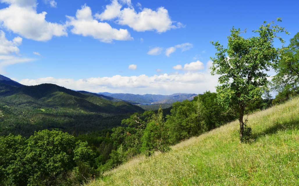
My wife and I took off that morning at a pretty good clip from the not quite completed Oak Knoll Trailhead. We started on the Mule Ridge Trail, which was pretty level as we wound through the typical northern California vegetation of Manzanita, California Black and Live Oak and Digger Pine. After about a mile we started our climb in earnest. It never got steep, just long switchbacks. After about two miles and a 700-foot gain, we were rewarded with views of the Sacramento Valley stretching south. Recent views show the scary damage from two fires; the Dale Fire and the more recent and devastating Clover Fire.
We continued on to a saddle that offered views of both the valley and Whiskeytown Lake and further northwest the jagged Trinity Alps. We followed the trail along the ridge for another couple miles until we came to a drainage and what looked like the end of the trail. That is where we saw the bear. It was probably a quarter mile away but heading toward us. Finally, after watching it for a minute I did my normal “Hey Bear” call and lickity-split it went up and over the ridge as easily as if he were running downhill.
At that point, we were not sure how much of the trail was completed so we went back the other way. Later we discovered that we were almost exactly halfway and yes, we could have continued on to complete the rest of the loop with a little more effort.
Nowadays, this is one of our go-to trails for a good three hours of hiking. The Mule Ridge Trail now connects to a fairly steep descent called Cosmos Way down to the level Princess Ditch Trail that follows a historic mining ditch from the Gold Rush days. This makes for about a 10-mile loop hike with enough hills to get a good workout. You finish back at the Oak Knoll Trailhead, which is now complete with picnic tables, vault toilets and ample parking with a turnaround for horse trailers.
To get to the trailhead from the Redding downtown area, take Placer Road 12 miles west to Mule Mountain Road. Trailhead parking will be on the left hand side a mile up. Bring the usual: hat, sunscreen, sunglasses, water and depending on the weather, rain jacket or fleece coat. It is a dog friendly trail which always makes Rufus the Border Collie happy.
For more information on this and other great BLM trails in the Redding area visit: http://www.blm.gov/ca/st/en/fo/redding/recreationmain/reddingrecreationtrails.html


