Susan River On The
Bizz Johnson Trail
By Melissa Wynn
[media-credit name=”BLM” align=”alignnone” width=”300″] [/media-credit]Whether you are a biker, hiker, walker, or just someone fond of wandering the woods, the Bizz Johnson Trail is gorgeous choice. This marvelously maintained trail winds along the rolling Susan River, over the mountains and through the woods from Highway. A21, just outside of Westwood, and runs to Susanville. Offering panoramic vistas along with great fishing and swimming holes, this has long been a favorite outing for locals. Bring a camera and snap a few shots of the railroad bridge that seems so out of place in this otherwise untouched, rugged terrain. Various opportunities to photograph wildlife exist. You will see them coming to the river to drink, and plenty of birds adrift on the winds. Bring a pole and wet a line; the fishing is great and you will find no crowds in this remote area of the Sierra. Maps of the Bizz Johnson Trail can be acquired at any Forestry Office in the area, or online.
For more information visit USDA Bureau
of Land Management, Eagle Lake Field OfficePhoto of Sardine Lake by Eileen Majors
Sardine Lake
By Eileen Majors
[media-credit name=”Eileen Majors” align=”alignnone” width=”281″] [/media-credit]We found an amazing spot for waterfront dining and lodging at Sardine Lake, off Gold Lake Highway, between Graeagle and Sierra City. They welcome seasonal guests each year to their unique, family-operated resort on the shores of Sardine Lake. The resort sits under the towering backdrop of the 8500-foot Sierra Buttes. In an area know for renowned fishing, many also enjoy hiking, bird watching, wildflowers, and scenic beauty. Guests are surrounded by unexpected opportunities to view soaring eagles and osprey, deer, otters, and a variety of wildlife. The main lodge opens daily at 8am for beverages, including beer and wine, and snacks. They carry bait and tackle, offer boat rentals, and cabin reservations. Sardine Lake Lodge offers a full menu of excellent dinners. Giant steaks and piles of prawns seemed to be a popular choice and there was not an empty seat in the dining room on the Thursday evening when we arrived. Reservations are highly recommended. Owned and operated by Chandler Hunt, Janis Boucher-Hunt and Tom Hunt, the resort is operated under special permit from the US Forest Service.
Gold Lake
Courtesy Of www.fs.usda.gov
[media-credit id=4 align=”alignnone” width=”300″] [/media-credit]Gold Lake Campground is located in the Lakes Basin Recreation Area. Located nine miles southwest of Graeagle, California, this recreation area has special geological features. There is breathtaking scenery and over 20 small lakes nearby, most of which are accessible by hiking trails. This area provides a multitude of recreational activities including camping, fishing, boating, hunting, mountain biking, horseback riding, picnicking, hiking, backpacking, swimming, wind-surfing, and nature study. In the winter visitors can snowmobile, cross-couintry ski, and snowshoe. This peaceful campground is located along the shores of Gold Lake at an elevation of 6400 feet. This campground has 37 sites. Fire rings, vault toilets, and garbage service is provided. There is no water or tables. For tables and outstanding scenery visit the Gold Lake Picnic Area. Bring the family and spend days exploring this historic area. This lovely spot is the perfect place to spread out your picnic and play.
Burney Falls
By Melissa Wynn
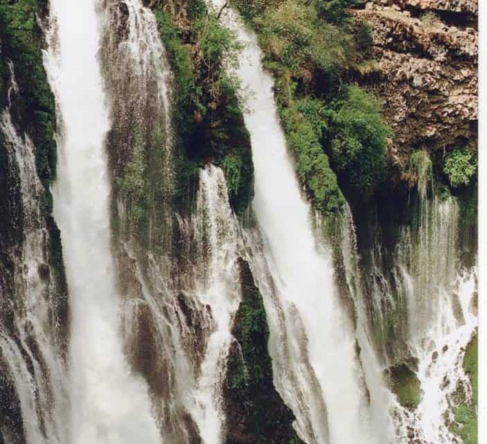
[media-credit name=”BenGraham” align=”alignnone” width=”300″] [/media-credit]Cascades of white water tumble over the hillside year ‘round creating Burney Falls. Natural springs from within the hillside add to the falls all the way down to the pool. A heavy mist hangs constant in the air, throwing rainbows in every direction. Hiking trails of various levels of difficulty offer countless views of the natural marvel. I love to walk the loop to the top. I continue to be amazed by the seemingly small creek that suddenly turns into one of California’s most majestic waterfalls. Bring a picnic and enjoy the woods at one of many picnic tables near the visitor center. More than just a waterfall, McArthur-Burney Falls State Park has 910 acres of forest and five miles of stream side and lake shoreline, including a portion of crystallline Lake Britton.
Rocky Point – Lake Almanor Campground
By Melissa Wynn
[media-credit name=”Eileen Majors” align=”alignnone” width=”300″] [/media-credit]Let’s load up the water toys and go camping lakeside at Lake Almanor’s Rocky Point Campground. Just like the name implies this gorgeous campground is nestled on a forested point with campsites nestled on the water, off the pristine West Shore, just North of Canyon Dam, on the East side of Hwy 89. Hosted by PG&E, Rocky Point Campground offers 131 sites for tents and RVs on a first come-first served basis. Looking for a lace a little less crowded for your larger group? Fear not, Rocky Point also offers two smaller campgrounds by reservation only. Rocky Point North offers only five sites for up to six people per site. Rocky Point South is a bit larger with 19 sites for up to six happy campers per site. All three are waterfront campgrounds offering boat launching, vault toilets, running water, and a dump station for RVs. For group site reservations call (916) 386-5164.
Deer Creek
Fun, Fishing and Falls
By Melissa Wynn
[media-credit name=”MarybethLaraway” align=”alignnone” width=”300″] [/media-credit]Looking for a leisurely hike in one of the most beautiful areas in the state? Take a ride along highway 32 from Chico to Chester and see the natural beauty of the area that Deer Creek calls home. Blooming Dogwoods line the highway beside moss covered, weeping, forested hillsides. Over four thousand feet of elevation change during this road trip offers a variety of plant and wildlife tha t is hard to beat in a short hour and a half journey. Simply breathtaking.Three cozy campgrounds in the conifers offer relaxing stopping points, and restrooms along the way (Potato Patch, Elam and Alder Creek). Watch for the sign for Deer Creek Falls, park in the pullout and enjoy the hike through the woods. Just follow the signs. These crashing crests in the creek croon a soothing tune to lull the senses. Bring a lunch and spend the day relaxing or pick a campground and spend a few days enjoying Deer Creek’s world class trout fishing.
Hat Creek
By Melissa Wynn Photos by Ben Graham
[media-credit name=”Ben Graham” align=”alignnone” width=”300″] [/media-credit]World class trout fishing attracts anglers from all around the globe to the Hat Creek area. This babbling brook of Northern California hosts many creek side resorts including luxurious Clearwater Lodge and kicked back Hat Creek Resort. Bring your favorite pole and tackle. Fish on! Several public picnic areas and campgrounds also dot this incredible area nestled in the Sierra cascade between Mount Lassen and Mount Shasta. Don’t forget to stop in for an educational visit to the Hat Creek Radio Observatory just off of highway 89 and learn how they study space by “listening” to the galaxy. A quick detour down Cassell Road brings you to the amazing junkyard art always on display at Packaway Materials Inc. The owner and his brother build a new sculpture each year. Ever seen a 28 foot ant or a full story snowman? There is nowhere friendlier than homey Hat Creek.


